The Greater Himalayan Range in Nepal
The Himalayan Range
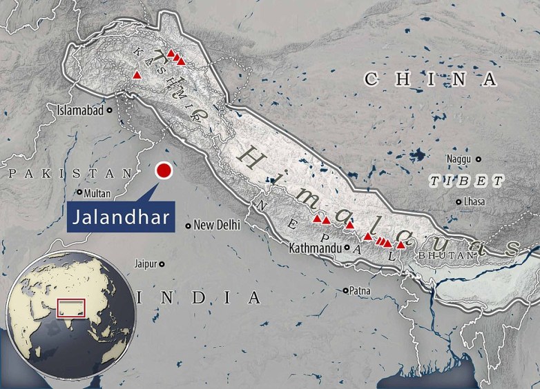
Dhauladhar range — one of the Lesser himalayan ranges — is about 125 miles from Jalandhar (shown above). This range emerges from the vicinity of Badrinath.
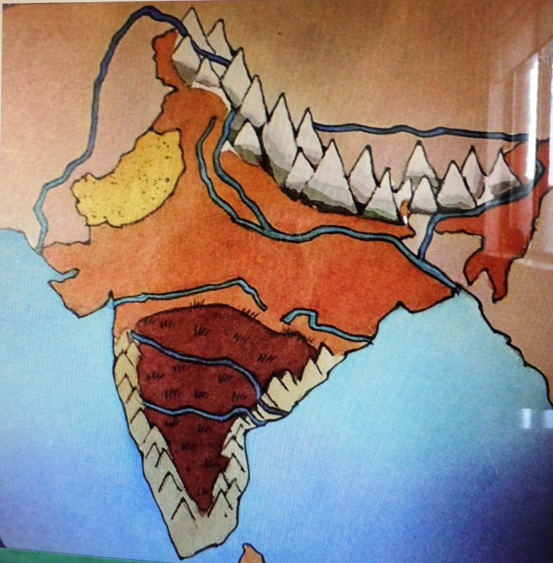
Map Of India: The Himalayas; The Ganga and Jumna rivers; The Indus; The Brahmaputra; The Narmada and the Mahanadi; The Godavari; The Krishna; The Western Ghat; Rge Deccan Plateau; The Eastern Ghat


The Himalayan Mountains
The Himalayas stretch for a distance of 2400 KMs from the Indian Gorge in the west to the Brahmaputra Gorge in the east. The width of the Himalayas is 500 KMs in Kashmir and 200 KMs in Arunachal Pradesh.
The Himalayas are divided into the Trans Himalayas, The Greats Himalayas or Himadri, The Lesser Himalayas or Himachal and the Shiwaliks and the Purvanchal Hills.

The Himalayas runs from west to east (2400 km)
- Northwestern or Kashmir Himalayashttps://en.wikipedia.org/wiki/Garhwal_Himalayas
- Himachal and Uttaranchal Himalayas
- Eastern Himalayas
But above them, disembodied in the haze, hovered the Garhwal Himalayas, part of the central Himalayan mountains, which serrate the borderlands of northern India before crashing into Nepal’s yet higher massifs immediately to the east.
The Himalayan Range in the Nepal
See Mt Everest from kala Patthar – the most accessible closeup view of Everest.
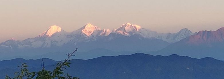
নেপালের নাগরকোট (Nagarkot) থেকে সূর্যদয় — Sunrise on the Greater Himalayas. Nagarkot is a village in central Nepal, at the rim of the Kathmandu Valley. It’s known for its views of the Himalayas, including Mount Everest to the northeast, which are especially striking at sunrise and sunset.
Creation Of The Himalayas
See the picture here

The Trans Himalayas
This range is also called the Tibetan Himalays because most of these ranges lie in Tibet. The Zaskar, the Ladakh, the Kailash and the karakoram are the main ranges of the Trans Himalayan System.
The Great or Inner Himalayas
This is the northernmost range and is also known as ‘Himadri’. This is the most continuous range. It contains the loftiest peaks. The average height of peaks in this range is 6,000 metres. The approximate length of the Great Himalayan range, also known as the central axial range, is 2,500 km from east to west, and their width varies between 160-400 km from north to south. All the prominent Himalayan peaks are in this range. See the range in Nepal below.
The Lesser or middle Himalaya or Himachal
The Lesser Himalayas(Himachal), located in northwestern India in the states of Himachal Pradesh and Uttar Pradesh, in north-central India in the state of Sikkim, and in northeastern India in the state of Arunachal Pradesh, range from 1,500 to 5,000 meters in height. Located in the Lesser Himalayas are the hill stations of Shimla and Darjiling . It is in this transitional vegetation zone that the contrasts between the bare Northern slopes and the forested Southern slopes become most noticeable.
- The general orientation of these ranges is from northwest to the southeast direction in the northwestern part of India. •
- Himalayas in the Darjiling and Sikkim regions lie in an eastwest direction, while in Arunachal Pradesh they are from southwest to the northwest direction. In Nagaland, Manipur and Mizoram, they are in the northsouth direction.
Average width of this range is 50 km. This range is mainly composed of highly compressed and altered rocks.
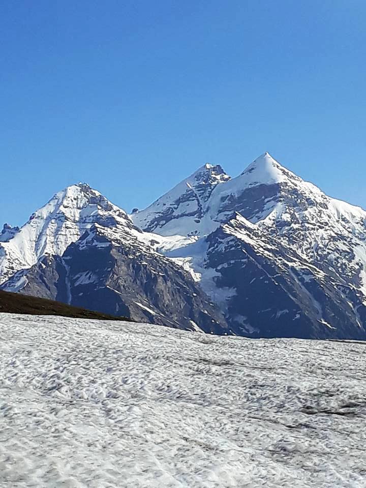
Major peaks of Garhwal Himalayas
The Shiwaliks
The Outer(Siwalik) or Southern Himalayas, averaging 900 to 1,200 meters in elevation, lie between the Lesser Himalayas and the Indo-Gangetic Plain. In Himachal Pradesh and Uttar Pradesh, this southernmost range is often referred to as the Siwalik Hills. It is possible to identify a fourth, and northernmost range, known as the Trans-Himalaya. This range is located entirely on the Qinghai-Xizang Plateau, north of the great west-to-east trending valley of the Yarlung Zangbo River. Although the Trans-Himalaya Range is divided from the Great Himalayan Range for most of its length, it merges with the Great Himalayan Range in the western section—the Karakoram Range—where India, Pakistan, and China meet.
The southern slopes of each of the Himalayan ranges are too steep to accumulate snow or support much tree life; .Between the ranges are extensive high plateaus, deep gorges, and fertile valleys, such as the vales of Kashmir and Kulu. The Himalayas serve a very important purpose. They provide a physical screen within which the monsoon system operates and are the source of the great river systems that water the alluvial plains south. As a result of erosion, the rivers coming from the mountains carry vast quantities of silt that enrich the plains.
The area of northeastern India adjacent to Mayanmar and Bangladesh consists of numerous hill tracts, averaging between 1,000 and 2,000 meters in elevation, that are not associated with the eastern part of the Himalayas in Arunachal Pradesh. The Naga Hills, rising to heights of more than 3,000 meters, form the watershed between India and Burma. The Mizo Hills are the southern part of the northeastern ranges in India. The Garo, Khasi, and Jaintia hills are centered in the state of Meghalaya and, isolated from the northeastern ranges, divide the Assam Valley from Bangladesh to the south and west.
| Peak | Country | Heigh (in m) |
|---|---|---|
| Mt. Everest | Nepal | 8848 |
| Kunchenjunga | India | 8598 |
| Makalu | Nepal | 8481 |
| Dhaulagiri | Nepal | 8172 |
| Nanga Parbat | India | 8126 |
| Annapurna | Nepal | 8078 |
| Nanda Devi | India | 7817 |
| Kamet | India | 7756 |
| Namcha Barwa | India | 7756 |
| Gurla Mandhata | Nepal | 7728 |
On the basis of relief, alignment of ranges and other geomorphological features, the Himalayas can be divided into the following sub-divisions:
- Kashmir or Northwestern Himalayas
- Himachal and Uttaranchal Himalayas
- Darjeeling and Sikkim Himalayas
- Arunachal Himalayas (v) Eastern Hills and Mountains.
- DHAULADHAR RANGE
-
Kangra Valley
- Chamba
- Dharamshala
-
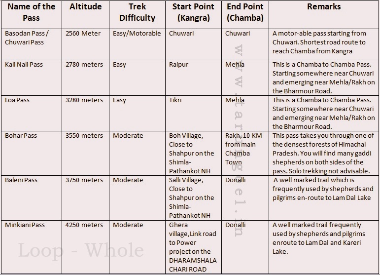
Passes of Dhauladhar Range
Pir Panjal Range
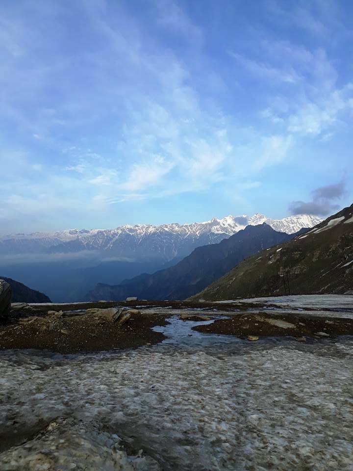
Rohtang Pass (elevation 13,051 ft), on the eastern Pir Panjal Range of the Himalayas 32 miles from Manali.
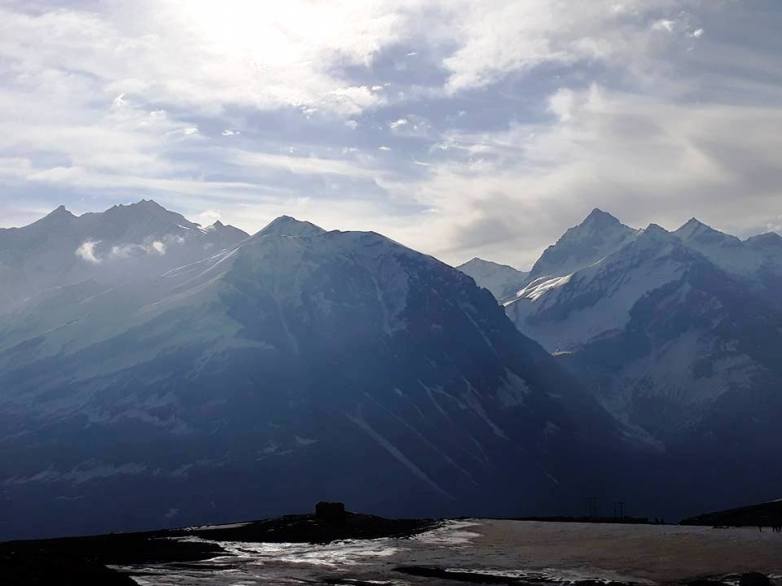
Pir Panjal Range from Rohtang Pass
A view from the Rohtang Pass
Himalayan Regions from West to East:
-
- Kashmir Himalayas: This part lies between the Indus and Sutlej. From west to east, this is also known as Kashmir Himalaya and Himachal Himalaya; respectively.
- Kumaon Himalayas: This part lies between Sutlej and Kali rivers.
- Nepal Himalayas: The greater Himalayas, this part lies between the Kali and Tista rivers.
- Assam Himalayas: This part lies between the Tista and Dihang rivers. (See
Physical Features of India – Chapter 2 Geography NCERT Class 9)
| Punjab Himalayas |
|
| Kumaou Himalayas |
|
| Nepal Himalayas |
|
| Assam Himalayas |
|
Eastern Hills and Mountains: The Brahmaputra marks the eastern border of the Himalayas. Beyond the Dihang gorge, the Himalayas bend sharply towards south and form the Eastern hills or Purvachal. These hills run through the north eastern states of India. They are mostly composed of sandstones. These hills are composed of the Patkai Hills, Naga Hills, Manipuri Hills and Mizo Hills.
See Six Incredibly Scenic Spots In Eastern Himalayas
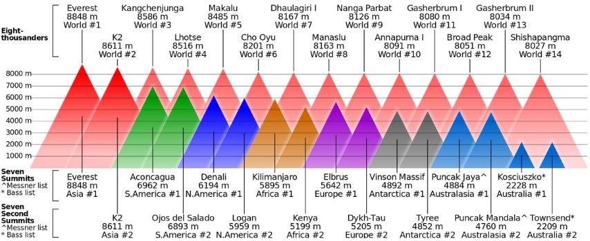
The Peaks in the World – Seven Summits
References
- Formation of Himalaya By Dr Tejbir Rana You Tube
- Plate Tectonics – How Mountains are Made You Tube
- https://en.wikipedia.org/wiki/Himalayan_foreland_basin
- http://directionias.com/uploads/study_material/05-28-42949345431.pdf

Orientation of Himalayas in Arunachal Pradesh is from southwest to northeast direction not southwest to northwest direction. There is mistake in NCERT textbook and same mistake is here.
LikeLike